David Ira Kagan, a retired English and mathematics teacher, has lived in Pine Creek's southernmost village of Torbert since 1991. He has written and published numerous articles on Pine Creek Valley, both of its history and of its life today.
He has also written and published of the past and of the present about people, places and events in the wider Lycoming and Clinton County area, mostly for the Webb Weekly and the Williamsport Sun-Gazette.
His three books, published in the "Images of America" series by the Arcadia Publishing Company, include his 2008 Pine Creek Villages, Sugar Valley Villages (published in 2011), and Middletown Borough (available as of July 20, 2009). The latter is about his hometown, which is near Harrisburg, Pennsylvania.

The Railroad Background of the Pine Creek Rail Trail
By David Ira Kagan On May 9, 1883, the Jersey Shore, Pine Creek and Buffalo Railroad was completed through Pine Creek Valley. On that day, a work crew from the north met one coming from the south at “Ross House,” about 10 miles north of Waterville. This main line allowed narrow-gauge logging railroads to be…
Experiencing The Pine Creek Rail Trail In Early April
By David Ira Kagan What is so very special about bicycling, walking or jogging along the Pine Creek Rail Trail at the beginning of April? When your spouse, your friends-even your enemies-tell you that you’re crazy, meshuggener, to be out there at this time of the year? When you need to wear gloves, woolen socks…
Time To Join Me On The Rail Trail
By David Ira Kagan Out on March 13th on the Pine Creek Rail Trail, I rode my bicycle for the first time since January 5th. Although still a bit soft in places from the downpour a week earlier and the melt-off of snow and ice, it’s now manageable from the southern terminus off Railroad Street…
An Old Cemetery Filled With The Young
David Kagan Utceter Cemetery, in western Lycoming County along Pine Creek just off the rail-trail one mile south of Slate Run, contains about 45-50 gravesites of 19th century pioneer farming and lumbering families. The names include Callahan, Tomb, Stradley, Hilborn and Herritt. Daniel Callahan, born in Ireland, was a Revolutionary War veteran who received a…
Pine Creek Valley Suffering From Marcellus Shale Gas Invasion Of Trucks
By David Ira Kagan On Wednesday, October 27, 2010, I sat on a folding chair at the White Tail Parking Access of the Pine Creek Rail Trail just off Route 44 a couple miles above Jersey Shore. And I counted for two-and-a-half hours-from 11:30 a.m. until 2 p.m. I counted water tanker trucks that barreled…
July 26th Ride of 117 Miles
David Ira Kagan At 8 a.m. on this beautiful summer day, I bicycled from my Torbert Village home northward, with the intent of going all the way to the northern terminus at Stokesdale Junction. Two flowers were blooming profusely all along the trail-Queen Anne’s Lace and Woodland Sunflower. Shortly after noon, I came across Paul…
Visit with Bob and Dottie Webber
By David Ira Kagan On July 27, 2010, this writer, his wife and two friends experienced the pleasure of visiting the legendary Webbers at their cabin home high above Slate Run on the west side of Pine Creek. From the left are Bob Webber, my wife Beth, Bob’s wife Dottie, and husband and wife Janice…
Drowned Rat Dave
By David Kagan Bicycling through rain. Through a downpour. Through a torrent. Through a deluge! The day? Thursday, July 23, 2009. The forecast that morning? Cloudy, with a 40% chance of a late afternoon shower. At about 1 p.m., I left my Torbert Village home, heading north up the Pine Creek Rail Trail. I thought…
Historical Sign at Ramsey Village
By David Kagan If you’ve bicycled past the village of Ramsey on the Pine Creek Rail-Trail since mid-summer of 2008, then you couldn’t help noticing the attractive sign at the access parking area. Professionally done by 21st Century Signs of Williamsport, bolted down, and anchored with two solid, thick wooden posts, it reads, “Circa 1790,…
Bicycling From Dawn To Dusk
By David Kagan Well, I did it! I bicycled along the Pine Creek Rail-Trail from my Torbert Village home to the northern terminus at Stokesdale just above Wellsboro, and then back again–117 miles, in 13 hours, on a beautiful September 17, 2008 day. Why? Partly as training for my fourth straight year of participation in…
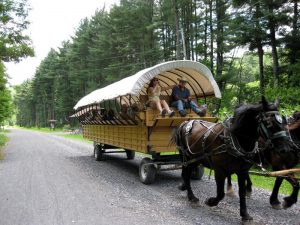
Blackwell Is Still The Blackwells’ Village
Pine Creek Valley is a wonderful scenic destination in Pennsylvania that everyone should visit. Pine Creek Valley itself begins near Ansonia where you will find the Pine Creek Gorge also known as the Pennsylvania Grand Canyon. The Canyon can be up to 1000 feet deep in some places. There are also many wonderful small towns…
Beware The Snakeroot!
By David Ira Kagan It’s a beautiful, native, white-flowered perennial herb. But it’s a poisonous plant (some consider it a weed) that can even kill. In fact, it’s notorious as the plant responsible for the death of Nancy Hanks Lincoln, Abe Lincoln’s mother! It’s the white snakeroot-also known as richweed, white sanicle, ageratina altissima, or…
Bicycle The New Section Of The Rail-Trail
By David Kagan The newest section of northcentral Pennsylvania’s rail-trail is now open to bicycling and hiking enthusiasts! Just under eight miles long, it lies in Tioga County and stretches between Route 6 at Ansonia and Route 287 just three miles above Wellsboro, passing through very scenic wetlands, farm fields and a small village. Marsh…
Little Pine State Park — Where Eagles Soar
By David Kagan Little Pine State Park, in western Lycoming County along Little Pine Creek four miles northeast of Waterville up Pennsylvania Route 4001, is a summertime wonderland. Covering 2158 acres in Tiadaghton State Forest, the park offers a variety of activities to its visitors—picnicking, hiking, swimming, boating, fishing and camping. Trails along the shore…